Day 2 of the 2020 trip to Eastern Washington
/Carol Hasenberg, Past President of GSOC and current Field Trip Director, visited eastern Washington recently with her husband John. They based the trip primarily upon the geologic topics covered in the “Nick From Home” video series by CWU professor Nick Zentner. If you’ve come in through the back door, i.e., Facebook or some other link directly to this page, you may want to start at the introduction page to the trip.
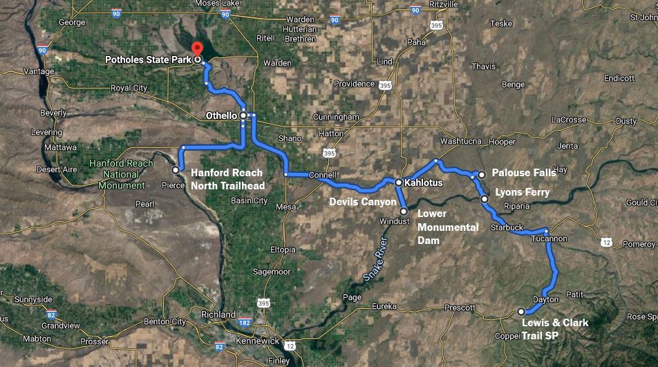
Day 2 overview map

My birthday present - a trip to Palouse Falls. Better than hearing that Beatles song!
I woke up this morning and I realized “Hey, it’s my birthday!” Sweet 64, and nobody playing that Beatles song for me. Oh, well. I looked at the Google weather forecast and the current temperature was 64 degrees. There you go!
This day I had prepared a nice birthday treat- Palouse Falls! I had wanted to see this for a long time. The day was beginning to be fine and hot, even though it had been a bit chilly the night before. This was the last time we could claim this on this trip. The weather forecast had begun to morph into the hottest week of the year scenario. Looked like 100+ weather through Thursday, and it was just Monday morning.

Looking up the Palouse River from Lyons Ferry Park.
John and I broke camp and headed up US 12, then cut NW on Hwy 261 towards Lyons Ferry, where the highway crosses the Snake River. This section of the Snake was affected by the Ice Age Floods- they backed up into the river and deposited much gravel, and several gravel bars and giant ripples can be found from Lyons Ferry and west along the river today. The Lower Monumental Dam impounded water on the Snake up past Lyons Ferry and into the Palouse River, which enters the Snake just east of the bridge. I did not see any obvious ripples on the sediments at Lyons Ferry, but the scenery was spectacular.
Just a few miles north of this is Palouse Falls on the Palouse River. The Cheney-Palouse floodway sent a massive flood of water down Washtucna Coulee to the north, and some of this overtopped and flowed over to what is now the Palouse Canyon on a shortcut to the Snake River. The blocky-looking erosion of the canyon and side channels of the Palouse is due to the water having taken advantage of the weak planes of faults that have cut through the Columbia River Basalt.
Nowadays the Palouse River Travels through a canyon several sizes too big for it to have carved, but the falls does the graceful 185’ drop into the over-sized plunge pool in a most scenic fashion.

Looking up Devils Canyon.
Fanciful colonade at Devils Canyon. Click to enlarge.
Another nearby feature, Devils Canyon, was carved by the floods in a similar situation to that of the Palouse River. We visited this narrow, straight canyon on our way down to the Windust Park area, where I had noted from Bjornstad that a flood-created gravel bar could be seen with giant ripples. The canyon had some very cool basalt colonnades creating fantastic patterns. These included intercanyon flows and straight columns with the look of an archaeological oddity.

Detail map of Kahlotus, Devils Canyon and Windust area.
We were pretty thrilled with all the features found on this little side trip down to Windust. Although the park at Windust was closed due to COVID-19, we parked alongside the road a mile or so below the park to snap pictures of the giant ripple marks in the gravel bar across the Snake River. Luckily a train came by and the cars make a great size comparison in getting the scale of the features.
After leaving Devils Canyon, we drove back to Kahlotus and west to the town of Othello, where we had lunch. An alternative route would be to travel down the Pasco-Kahlotus Highway, seeing more flood features in the Snake River Canyon. Refer to Bjornstad’s Road Tour 1: Palouse-North Snake River.

Interlaced fan-shaped jointing patterns in the basalt in Devils Canyon.

Giant ripples in the gravel bar across the Snake River from Windust. Below the eroded face of the ripples you can see the cars of a passing train for scale.

Hanford Reach just seemed too hot today.
We found a nice spot for lunch in Othello in a nice shady city park. Othello also had grocery stores, gas stations, and all the amenities. It is also smack in the middle of the Columbia Basin Project, and the effects of having water for irrigation were everywhere. Like the green city park. Like thousands of acres of crops, mostly fruit trees, everywhere. Er well, almost everywhere. On the hills and plains of loess that had not been stripped by the Ice Age Floods, or the large basins that had received deposits of the loess by the floods.

Ricas Frutaletas & Ice Cream treats in Othello - highly recommended!
We had plans to go after lunch to Hanford Reach National Monument, because there on the north banks of the Columbia River are the White Bluffs, and the white coloring is from deposits of the Ringold Formation, remains of a Pliocene lake (3-8 Ma.) that covered the Pasco Basin. We drove south to the turnoff for the North Trailhead, but by then we were into triple digits temperature-wise. That gravel road just was not very appealing right then. Instead, we went back to Othello and the ice cream store we’d scoped out earlier. Alas, I did not get another chance to see the Ringold Formation on the trip.
Drumheller Channels scene. Click to enlarge
After downing the birthday ice cream treat, we took off for the campground at Potholes Reservoir SP. Our route took us through the Drumheller Channels, a major scabland south of Potholes Reservoir. Sagebrush was the most prevalent crop in this wild region. It was here that Ice Age Floodwater poured south after exiting the Grand Coulee at Ephrata.
We finally made it to the campground at Potholes Reservoir SP. We had carefully chosen the campsite most isolated from the others in the tent camping loop. This was good from the noise and COVID-19 isolation standpoint. We had hoped to swim in the reservoir, but there was only a boat ramp and no beach. But the showers were nice and refreshing! Although I’ll warn you there was no hot water. The majority of campers were in the RV loop and they had their own showers, so there were not a lot of people using them.
Click here for Day 3.


