Day 3 of the 2020 trip to Eastern Washington
/Carol Hasenberg, Past President of GSOC and current Field Trip Director, visited eastern Washington recently with her husband John. They based the trip primarily upon the geologic topics covered in the “Nick From Home” video series by CWU professor Nick Zentner. If you’ve come in through the back door, i.e., Facebook or some other link directly to this page, you may want to start at the introduction page to the trip.

Day 3 overview map
I rubbed my hands when waking up this morning. This was the gravy day! We were to travel a loop around the Quincy Basin, looking at many Columbia River Basalt and Ice Age Floods features, and there were several hiking possibilities. A bit dampened by the fact that the high temperature today was to be 102 F.
Boulders spewed out in the Ephrata fan. Click to enlarge.
A good background for this trip can be found in Alt pgs. 133-141. When the Okanogan Lobe of the Cordilleran Ice Sheet filled the northwest Columbia channel, floodwaters swept down the Grand Coulee, sprayed out of this channel at Ephrata (dumping sediment as it lost energy), and surged into Quincy Basin. The water was impeded by the Frenchman Hills and then the Saddle Mountains on its way south and down, so it skirted these obstacles by falling into the Columbia channel to the west in Potholes Coulee, Frenchman Coulee, and a few other spots, and flowing across the Potholes Reservoir and Drumheller Channels to the east. All this action makes for some pretty dramatic scenery.
We started the tour du jour by heading east across the top of the O’Sullivan dam, which today holds a lot of water used in the Columbia Basin Project, then connected with Hwy 17 heading north through the town of Moses Lake to Ephrata. For several miles outside of Ephrata, the barren fields are filled with boulders dumped by the floods.

West Bar overlook at Trinidad - there’s no way to show the scale of this scene from a picture on the web. The giant ripples on West Bar were made by the last Ice Age Flood to surge down the Columbia, and not the stronger larger earlier floods.

Detail map of West Bar overlook.
We then headed west from Ephrata through Quincy to the little town of Trinidad on the lip of the Columbia Gorge. Heading down towards the Crescent Bar Resort on the river, there is a beautiful overlook just past the switchback. A vast bend in the Columbia River is filled by a huge flood gravel bar, and the giant ripples on its surface are at least two miles from the observer.
Still in awe from this scene, we headed back toward Quincy and turned south onto White Trail Road to our next destination, Potholes Coulee. There are a number of hikes outlined for this area in Bjornstad, and we chose Trail Q Judith Pool Trail because it was short, pretty flat, and had planed off Roza flow columns you could stand on. We figured we could make it there and back without dying from heat exhaustion.

Map to Judith Pool trail in Potholes Coulee. The only sign marking this trail was a punched metal sign which said “Ancient Lake Trail” by the gate.

Lucy and I are ready to go! Included in this shot is the only sign identifying the trail, and “Ancient Lake Trail” is a misnomer because the Upper Ancient Lake trailhead is actually about a mile down the road.
And we were not disappointed by the sights we saw on the hike. It started blandly travelling west down a small coulee, then the trail crossed from the south to the north side of the coulee, past a former diatomite mine, and ended at the Judith Pool with dramatic views down the coulee to the Columbia River. I especially liked the flood-polished tops of the Roza flow columns at the outlet falls of Judith Pool. Also, the vegetation was lush around the pool, which must be receiving water from the Columbia Basin Project (the lakes east of the road are impoundments in the system), and it included some beautiful purple-flowering plants. The diatomites and opalized chert that were mined in the area came from the deposits of lakes which formed between flows of the Columbia River Basalt.

The old diatomite diggings with Lucy for scale.
Anyway, not bad for a two mile hike. We were good and toasted when we got back to the shade of the large cottonwood tree where we had parked the car. We backtracked to the White Trail Road and headed east to I-90. It was time to pick a lunch spot and the only town between Potholes Coulee and Frenchman Coulee is George, Washington. (It wasn’t until I wrote this article that I figured out why they named it George!)

Left to right: Judith Pool, outlet falls over Roza columns, Ancient Lake Basin, Potholes Coulee.
Closer view of the outlet falls with John for scale. Click to enlarge.

George, Washington has a beautifully irrigated city park where we stopped for lunch.
Lunch was enjoyed in a beautiful green city park in George. The only other people there were from a couple of government trucks - BLM, maybe?

Once again, it’s really hard to capture the scale of the landscape with a photo, but here’s my attempt with a photo of John looking down Frenchman Coulee. What a waterfall it must have been!
The rest of the sites we had planned to visit that day were car stops and very short walks. Our next stop was right along I-90, so we got back on the freeway heading east towards the Columbia River. The thermometer in the car read 102 F.
Our destination was a short 6 or 7 miles from George. It is called Frenchman Coulee and Nick Zentner did a ‘Nick From Home’ episode #52 there in which he was actually away from home and walking around with his iPhone strapped to “the gadget." Nick spent most of his Frenchman Coulee episode in Echo Basin just to the south of Frenchman Coulee.
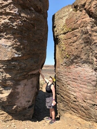
We stayed in Frenchman Coulee and took a short walk up to the ‘Feathers,’ a line of Roza columns sticking up above the surrounding terrain, survivors of the cataclysms. The columns did not look that big from the road but they sure were huge up close! I wonder what Stephen W. Morris, the J Tuzo Wilson professor of physics at the University of Toronto, would make of the parameters affecting the size of basalt columns. Will have to see that video again!
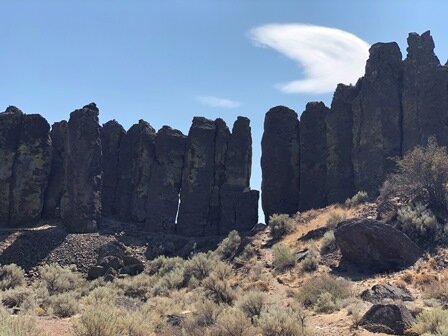

Upriver view of the cliffs on the west side of the Columbia River. It looks like the valley cleaving the cliffs is taking advantage of an area weakened by the abrupt increase in dip in the cliffs to the north of the gap, a cross-section through the Frenchman Hills Anticline.
Back to I-90, and this time we were planning to visit the Ginkgo Petrified Forest SP near Vantage, Washington, across the Columbia River on the west side. But after a few miles, when the freeway was beginning to make its descent into the Columbia Valley, there was a scenic lookout and so we took that. There was another huge vista here and I’ve included a couple of photos, and find the view southward down the river to Sentinel Gap to be nostalgic. I believe I have a photo of the 2002 trip to Wenatchee that features the Sentinel Gap; it was used as a GSOC banquet photo that year.

Downriver view of the I-90 bridge at Vantage and the Sentinel Gap beyond. Nick fans, which came first, the Saddle Mountains or the Columbia River?
Homage to Professor George W. Beck. Click to enlarge.
We finally got to the Ginkgo Petrified Forest SP, and at the Visitor Center there was a little display dedicated to Professor George W. Beck, a predecessor of Nick Zentner at CWU. He was the man responsible, in the 1930’s, for getting state protection for the petrified wood that can be found at the base of the Ginkgo flow of the Wanapum Basalt, and this flow takes its name from the gingko logs preserved at the site, along with several other species of wood of the Miocene in Oregon.
The museum also contained many samples (ie, polished trunk sections and others) of the buried forest and other Pacific NW petrified wood. The park also had an interpretive walk where you could see petrified wood in situ about a couple of miles from the Visitor Center. The SP rep told us we could see several not far from the trailhead (the trail was 3 miles long). So, we went out there and saw the in situ petrified trees, surrounded in thick metal cages so they would not walk out of the park. Lucy was a bit confused about why we would want to walk in molten heat to look at stumps in cages. Humans!

Lucy inspecting the caged stumps. What the?!?
We got back in the car and checked the temperature readout. 102 F. Time to get back to the campground and chill!
We drove east towards Othello and noted all the fields of espaliered fruit trees on the way. They had trained the trunk and branches of each tree on a grid that leaned out slightly towards the aisles to aid in the picking of the fruit. I regret not getting a picture of this.
Back at Potholes SP, we decided to spend the rest of the daylight at the well-watered picnic area and just come back to the camp for bedtime. I had spent about 20 minutes that morning picking foxtail grass seeds out of Lucy’s paws from the campsite. Plus, it was so green and nice at the picnic area and we were the only people in it. It put a beautiful end on a fruitful day.
Click here for Day 4.

Lucy is happier in this scenario, and so are we!


