Hawaiian Submarine Landslides and the Great Crack of Kilauea
/by Carol Hasenberg
Or, what goes up must come down!

USGS diagram from “Imaging the Sea Floor,” showing the extent of landslides around the Hawaiian Islands. The actual image, from the same article, produced by the side-scan sonar of the large landslide in the box is shown below.
This article came about by Sheila Alfsen asking me to include some information about the Great Crack of Kilauea, which might interest some of the membership when they are visiting the Big Island of Hawaii. I didn’t feel I could do justice to the topic unless I also covered the great landslides, produced by volcanic spreading, on the ocean floor surrounding the Hawaiian islands.

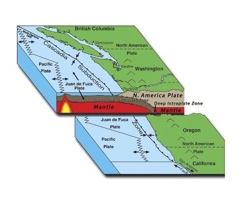
The knowledge of landslides around the Hawaiian islands did not come about until the 1980’s. As a result of then President Reagan’s refusal to sign the Law of the Sea Treaty proposed by the UN in 1983, and subsequent announcement that the US would be declaring a 200-mile Exclusive Economic Zone around all of its territories, the USGS was tasked with mapping those underwater zones. They did so with a relatively new technology, side-scan sonar, which has fairly good resolution for mapping large blocks of material on the ocean floor.
Not only did the side-scan sonar find evidence of landslides about the Hawaiian islands, but their runout distances in the hundreds of miles in some cases, and also the shapes of the islands themselves, indicated that this was a commonly occurring, and in many cases, a catastrophically impacting event in the life of a marine volcano.
I’ve already described the basic processes which drive the landslides on these volcanoes in the previous article. Geologists have also been gathering evidence on the forms these landslides take, and break them down into two types: gradual slumping of blocks of material from the sides of the volcano in which large blocks of material stay relatively intact, and catastrophic debris avalanches which break material up into smaller, chaotically jumbled and scattered remnants.
It is the second of these types of landslides which are feared to have formed giant tsunamis that can wash up, and in some cases, over some of the islands. There is some evidence of these having happened in the past where large chunks of coral have been deposited hundreds of feet above sea level.
One of the articles I read in preparing this piece was written in the mid 2000’s (see “Slope failure and volcanic spreading along the submarine south flank of Kilauea volcano, Hawaii,” below) in which the authors researched the composition of the south flank of the Kilauea volcano and what the likelihood of a catastrophic failure would be on the south flank. Luckily, the researchers have found evidence that such a failure did occur in the geologically recent past (10-50k years), but the material that fell formed a shelf that is buttressing the volcano against future catastrophic failures, unless the volcano should become very large.
We visitors to Hawaii can rest a little easier knowing that, and also we can visit the Great Crack in the Kau Desert area with some assurance that the island flank is not in imminent danger of cracking and falling away from there.

The Great Crack as seen from the air. From NASA’s virtually Hawaii project.
The crack is 6 miles long and is a surface expression of the currently quiescent Southwest Rift Zone of Kilauea. It’s easy to spot on Google Maps and if one follows the line it makes, one can see that there is a series of cracks terminating in the Kilauea summit caldera (although the Great Crack is a segment of the cracking further downrift of the section that runs into the caldera).
The crack is really impressive in size, 60 feet wide and 60 feet deep in places, with lava tubes cutting through it and other such features. The NPS has recently acquired the land on which it sits, so they will hopefully develop trails to it for Hawaii adventurers.
References and Additional Reading
Oregon State’s reference page on “Hawaiian volcanism” is a very detailed article on the subject. It contains a discussion about the giant landslides near the end.
“Evolution of Hawaiian Volcanoes” page from the USGS HVO website has a basic discussion about volcanic evolutionary stages and destructive processes.
John S. Schlee, Herman A. Karl, and M.E. Torresan, “Imaging the Sea Floor,” U.S. Geological Survey Bulletin 2079, *U.S. G.P.0., 1995. Describes using the GLORIA side-scanning sonar to map US territorial waters from 1986-1991. The Hawaiian landslide images used in this article comes from this publication, and this sonar mapping work revealed the presence of these massive underwater landslides to the geologic community. Modern sonar techniques employ both side-scan and multibeam techniques.
Moore, J. G., Normark, W. R., & Holcomb, R. T., “Giant Hawaiian Landslides,” Annual Review Of Earth And Planetary Sciences, Volume 22, pp. 119-144, 1994. This article summarized discovery and knowledge of giant Hawaiian landslides in the mid 1990’s, and is referenced quite frequently.
Julia K. Morgan, Gregory F. Moore, David A. Clague, “Slope failure and volcanic spreading along the submarine south flank of Kilauea volcano, Hawaii,” Journal of Geophysical Research: Solid Earth, September 5, 2003. This article discusses the particulars of the ongoing volcanic spreading in the south flank of Kilauea. It is quite technical, but from summary remarks appears to have been motivated, at least in part, to assess the slope stability of the south flank.
“Giant Landslides of the Hawaiian Islands,” from Dr. Ken Hon’s Geology of the Hawaiian Islands GEOL 205: Lecture Notes. Great introduction to this topic, well-illustrated and very easy to read.
“The Great Crack Hike in Ka'ū,” hike description found on the tourism website Instant Hawaii, contains some great pictures of the crack. No doubt the acquisition of the crack by the NPS will change the hike description somewhat, however. See next reference.
John Burnett, “National Park Service acquires ‘Great Crack Property’ in foreclosure sale,” Hawaii Tribune-Herald, Friday, September 14, 2018, 12:05 a.m.


Field Trip Director
Annual Newsletter Editor
fieldtrips@gsoc.org