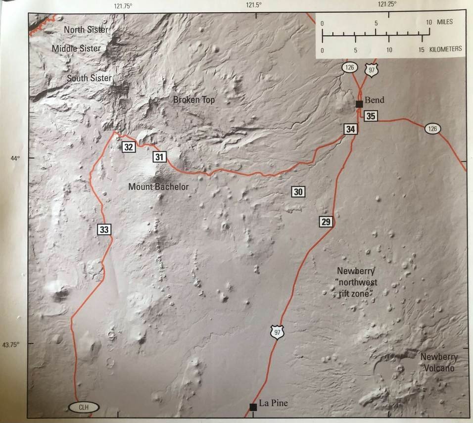
The Major Geologic Events of Death Valley
/A Beginner’s Guide
Death Valley National Park, the largest in area in the lower 48, boasts the lowest point in North America and the world record hottest temperature. It is also the driest desert in North America, contains relief of over 11,000 feet and exposes a remarkably full geologic history spanning 2.5 billion years (2.5 Ga.). The faults that created it are part of a system that in time may become the plate boundary between the Pacific and North American tectonic plates. Significant fossil finds from many different time periods have been made in the park. The combination of all these features make it one of the most geologically valuable sites in North America.

Andrew Dunning presented from “Death Valley”, or the next best thing (DV background on Zoom).
GEOLOGY OF DEATH VALLEY ONLINE
GSOC was privileged to have an excellent speaker in the form of Andrew Dunning, a recent graduate of geology at Portland State University, a former counselor at Camp Hancock who helped leading tours of this area in the September 2018 GSOC field trip there, and the creator of the Better Geology YouTube channel which we have referenced in previous articles, speaking to GSOC online at the May 2020 Meetup get together. Dunning also had the advantage growing up in Orange County, California, and visiting Death Valley numerous times throughout his young life to be able to take the audience on a thoroughly satisfying geotour of the area.
Zabriskie Point and badlands of light-colored Cenozoic playa sediments of the Furnace Creek Formation. Author photo.
There are different ways to approach explaining the geology of Death Valley, whose rock history stretches way back possibly into the Paleoproterozoic Period, and also contains a nearly complete sequence of strata stretching from 1.3 Ga to the Permian period, 252 Ma. One might begin by describing Death Valley as a pull-apart basin whose modern topography began to take shape about 16 Ma. with the crustal extension and faulting that resulted when the Farallon tectonic plate was completely subducted by the North American plate in the vicinity of California, and the formation of the San Andreas fault. One can also describe the various regions of the Death Valley National Park in discrete physiographic units or units accessible from a particular route and proceed from there. The problem with these approaches is that one tends to de-emphasize the importance of the evolution of the area through the depths of time. So, the approach Dunning took by laying out the geology of Death Valley from deep time forward has great validity in understanding its importance in revealing tectonic processes in earth’s history.
RODINIA ASSEMBLY AND BREAKUP

Layers in the Pahrump group found in Johnson Canyon of the Panamint Mountains. Photo by Andrew Dunning.
Death Valley contains surface exposures of metamorphosed Proterozoic basement rock. The post-metamorphic dates given for this highly deformed material is 1.7 Ga., although there are trace dates of about 2.5 Ga., leading some investigators to believe that this area was a cratonic microplate (Mojavia), one of the building blocks of Laurentia (North American continent), or at least assembled atop subsurface fragments of older material. By approximately 1.7 Ga., Mojavia was accreted to the North American continent.

Generalized columnar section of Precambrian to Lower Cambrian strata, Death Valley region, from L. A. Wright,1 B. W. Troxel, E. G. Williams, M. T. Roberts, P. E. Diehl, “Precambrian Sedimentary Environments of the Death Valley Region, Eastern California”, published in California Special Report 106 (see references).
A gap in the sedimentary record occurred between 1.7 and 1.3 Ga., and the only material from that time are some dikes and plutons that intruded into the basement rock at about 1.4 Ga. Then additional, less deformed sediments began to accumulate in a shallow oceanic basin. A continuous record of these sediments to 1.08 Ga. exists in the Crystal Springs Formation of the Pahrump Group. The sediments consist of conglomerate, then sandstone grading to mudstone in the lower strata. Layers above these contain thinly bedded limestone with remains of microbial mats (stromatolites) and microfossils. These rocks were then intruded by diabase sills at about 1.0 Ga. and the heat cooked the surrounding carbonate rock into talc, which has been extensively mined in the area. The basin that accumulated these sediments may have been an extensional feature called an aulacogen, or failed crustal rift; although a more recent interpretation is that of an oceanic basin between converging continents in the assembly of the Rodinia supercontinent.
Another gap in the sedimentary record occurred between 1.08 Ga. and 787 Ma. Then the remainder of the Pahrump group (ending at 635 Ma.) records the beginning of the breakup of Rodinia and several other important geologic and evolutionary events. In the sequence of supercontinent breakup, the western coast of North America began to rift away from neighboring continents to eventually form a passive continental margin. In the Horsethief Springs (formerly the upper Crystal Springs) Formation, the Beck Dolomite, and the Kingston Peak formation the sedimentary and fossil record makes these outcrops “an iconic record of Neoproterozoic environmental change.” The rise of multicellular organisms appeared during this time.
SNOWBALL EARTH

Around 750 Ma., the accumulation of diamictites and dropstones in the Kingston Peak Formation strengthens the evidence for the “Snowball Earth” or “Slushball Earth” scenarios, when Sturtian glaciation nearly or completely covered the earth. Scientists studying these periods have been in the process of carefully dating and recording the fossil content of the stratigraphy during this time to develop a picture of the changes to the biota before, during, and after the event, and understand causal relationships between life forms and the earth’s climatic changes. A second major period of glaciation, the Marinoan glaciation, is postulated to have occurred around 635 Ma. and this event is recorded in the uppermost strata of the Kingston Peak Formation (and the Pahrump Group). Much more research is being conducted on these theories and the role of Death Valley strata in them, and we look forward to hearing about progress in the years to come.
The Death Valley strata that span the remainder of the Neoproterozoic and the Paleozoic Eras record accumulation of sediments from a passive tectonic plate margin as Laurentia travelled from its role in the supercontinent Rodinia to the assembly of the supercontinent Pangea in the Permian Period. The Noonday Dolomite is the first formation of the sequence, and its age is that of the Vendian (Ediacaran), the age of the earliest multicellular life. The Noonday Formation is believed to contain in its lowest member the “cap carbonate” layer formed when earth recovered from the global glaciation periods. The reader is referred to the Wikipedia article “Snowball Earth” for discussions about this and other mechanisms involved in the process of initiating global glaciation and recovering from the same. Towards the southwest the outcrops of upper Noonday Dolomite become the Ibex Formation, a deeper water counterpart.

Noonday Dolomite polished in Mosaic Canyon contains clues about the end of global glaciation in the Vendian Period. Author photo.
The contact between the Noonday and the underlying layers is also interesting, as it is an angular unconformity. In the southern end of Death Valley, the Noonday overlies the Kingston Peak Formation conformably but as one goes north it overlies progressively older layers, until it rests directly on the basement rocks. This would indicate that an upland had been formed in the north in the ancient Pahrump time and its highlands had eroded down to the Proterozoic basement complex. In Mosaic Canyon it is the Noonday Dolomite that is polished in the narrows area.

Structures and fossils of the Paleozoic in Death Valley area. Photos by Andrew Dunning.
PALEOZOIC ERA AND THE FOSSIL RECORD
Sedimentary formations which complete the sequence from the Neoproterozoic through the Permian period are the Johnnie and Stirling Quartzite, also of the Vendian (Period); the Wood Canyon, Zabriskie Quartzite, Carrara, Bonanza King and Nopah Formations of the Cambrian; the Eureka Quartzite and Ely Springs Dolomite of the Ordovician; the Hidden Valley Dolomite of the Devonian and Silurian; the Lost Burro and Tin Mountain Limestone of the Mississippian; and the Resting Spring Shale of the Pennsylvanian and Permian.
This sequence of formations make a nearly continuous sedimentary record of a continental passive margin during the entire Paleozoic Era. From the Noonday Formation, the paleontological record has proceeded from the stromatolites and microfossils found therein to limited amounts of Ediacaran fauna in the Stirling Quartzite and finally, in the Wood Canyon Formation and above, the more familiar trilobites and other fauna of the Cambrian explosion, starting about 540 Ma. The record of marine fossils continues in nearly every one of the these formations, making this area an invaluable one to paleontologists. The sedimentary record reveals sea level fluctuations as well as periodic episodes of emergence from the ocean as demonstrated by fluvial braiding and other terrestrial processes.

Mosaic Canyon parking lot in 2003. A fault runs up the cleft in the hills, with the Stirling Quartzite and Johnnie formations on the left and the Noonday Dolomite on the right (info from Geology Underfoot). At the edge of the parking lot cemented terraces from debris flows out of the canyon lithify quickly from cementation of the carbonate content of the material. Author photo.
THE BIG CRUNCH OF THE MESOZOIC
Then, beginning in the Permian Period at about 250 Ma., tectonic forces transformed this slowly changing undersea world forever. The supercontinent Pangea had assembled, and the west coast of North America was about to become an active plate margin. The landscape underwent violent transformations, but shaped itself into something we can more closely recognize today when we visit Death Valley NP. Although there is no sedimentary record for the Mesozoic Era in Death Valley, the effect of the tectonic processes on the previous stratigraphic record is clear to see in the folding and faulting that occurred during this time. The forces induced onto the North American continent by the subducting Farallon Plate was the cause of the massive compression. Also, the Sierra Nevada Mountain Range was forming in a similar manner to that of the Cascade Range today, and plutonic bodies intruded into the older strata as far east as the western mountain ranges of Death Valley NP. Uplift also occurred, and Death Valley was transformed from a continental shelf environment to a terrestrial landmass and has remained so to this day.

The older strata in Death Valley all show evidence of folding and thrust faulting that took place in the Mesozoic. Author photo.
So, Death Valley would not be a good place to look for dinosaur fossils, although Dunning pointed out that there have been dinosaur tracks found in sandstone south of the park. However, the igneous intrusions of the Jurassic and Cretaceous did cause a lot of metals to be deposited around their margins. There was a lot of mining done in Death Valley in the days of the Wild West, and interesting features along with the geology are the ghost towns from those days. Tourists of today also enjoy driving through Titus Canyon, which has a remarkable recumbent fold in the strata in which the older layers sit almost horizontally atop the younger layers.
In the north part of Death Valley NP, one can find sediments as old as the Late Eocene, the Titus Canyon Formation (38-35 Ma.). This formation consists of conglomerates, breccias, sandstones and finer strata. It was in this formation that the titanothere Protitanops curryi, a large rhino-like mammal, was discovered in 1935. Many other fossils, such as Mesohippus, an early horse, have also been discovered in this formation. During this time, the terrain that comprises Death Valley today was relatively flat and uniform; the valley that we know today had not developed yet.
DEATH VALLEY FORMS IN THE MODERN TECTONIC ENVIRONMENT
During the Miocene at about 16-18 Ma., Death Valley began to transform itself into the valley we visit today. This process was also driven by tectonics. By about 20 Ma., the Farallon Plate had been consumed, and the Pacific Plate and the North American Plate were forming a strike-slip plate boundary, which we know as the San Andreas Fault. What had once been a compressional stress field now became a shear zone, with a right lateral movement direction. This shear zone has enlarged to affect the motion of most of California, and today up to 25% of the shear stress has been accommodated by motion on the strike-slip faults of the Eastern California Shear Zone and the Walker Lane Complex, of which Death Valley is a part. Some speculate that eventually the Pacific and North American plate boundary may be located east of the Sierra Nevada.

Various Cenozoic sediments in Death Valley area. Fossil footprints found in the Panamint Mountains and the Black Mountains are extraordinary. Photos by Andrew Dunning.
It was also during the Miocene that the Basin and Range physiographic province developed in the western interior of the continent, which is characterized by east-west crustal extension. Certainly, the elimination of subduction compressive stress was a factor in its creation, and other tectonic processes may have been involved, since the subducted Farallon plate was freed from its western edge constraints over a large area. So the creation of the valley was a product of the shearing of the western margin of the continent plus the extension happening in the interior. Today strike-slip fault zones combine with normal faults to produce a trapezoidal “pull-apart basin” that is Death Valley proper, and several other valleys in the vicinity were formed in this manner.
Getting back to the stratigraphy, the valley formation enabled sediments to collect and form rock. Conglomerates from alluvial fans (“fanglomerates”) and playa and lake sediments are present in Miocene deposits. Also regional and local volcanic centers spewed ashfall tuffs and basalts into the valley sediments. Artist Drive and Furnace Creek Formations contain playa sediments and igneous tuffs from the early to mid-Miocene. Other Miocene to Pliocene formations include the Nova Formation, the Funeral Formation, and the Copper Canyon Formation. The Copper Canyon Formation contains one of the world’s most valuable animal track sites from about 5 Ma.
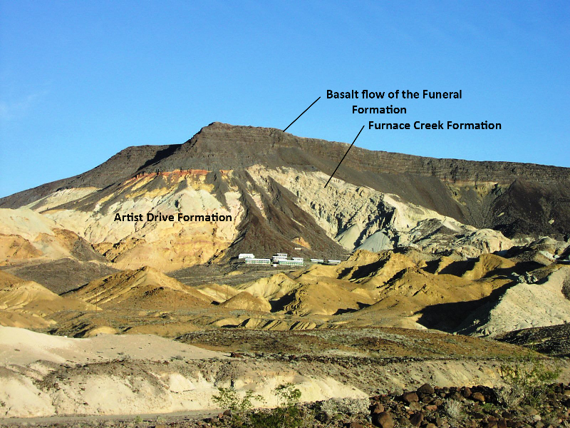
The author’s photo of Ryan Mesa and mining camp east of Zabriskie Point taken in 2003. Marli Miller had a similar photo showing the Cenozoic sediments and this photo is labeled in a like manner.
PLEISTOCENE LAKES IN DEATH VALLEY AREA
Death Valley was filled by a large Pleistocene lake, Lake Manly, which waxed and waned in the valley for at least 200 ka. At is largest extent, it was up to 600 feet deep. Many lakes existed in the other valleys of the area, and they were much interconnected by streams and channels. Lake Owens, Lake Searles, Lake Panamint, Lake Tecopa and Devil’s Hole in Nevada were part of that system. We know they were connected because of the desert pupfish. These hardy descendants of a formerly larger population inhabited the vast system of lakes and streams. They hang on in isolated colonies in Owens Valley, Salt Creek, Saratoga Springs, and Devil’s Hole.

Bajada on the west side of Death Valley. Author photo.
DEATH VALLEY TODAY
Lake Manly dried up about 15 ka., although a much smaller remnant lingered on until about 2000 years ago. People of the Clovis Culture inhabited the valley starting about 9000 years ago. But today the forbidding topography and parched climate discourages permanent habitation. The once abundant waters of the lake have dried into a thick and forbidding salt pan with place names like Badwater and The Devil’s Golf Course. The valley floors are nearly flat playas, filled by thousands of feet of sediment. The valley sides are bounded by strike-slip and normal faults. Features of normal faulting include faceted spurs, wineglass canyons, alluvial fans and fault scarps which cut across the fans. The eastern face of the Panamint Mountains (which form the western side of Death Valley) is bounded by a massive bajada constructed of old alluvial fans which have merged into a continuous slope. Several dune fields exist in the valley floors with sand dunes up to 700 feet in height.

Author standing on the Devil’s Golf Course in 2003. These salt deposits from Lake Manly, which have buckled from growth of the salt crystals are unexpectedly craggy. Telescope peak and the Panamint Range rise 11,000’ in the background. Author photo.
Vulcanism is also a common feature of today’s Death Valley, and there are volcanic features that are as young as several thousand years. Ubehebe Crater, on the north side of the park, was blasted out of Miocene basin sediments by a phreatic explosion several thousand years ago. Several cinder cones dot the same area. Badlands were carved from Miocene ashfalls and lake sediments. The geology of Death Valley continues to evolve and change with time.
AUTHOR’S COMMENTS ON THE GEOLOGY OF DEATH VALLEY
The author visited Death Valley in 2003, and the things that she noticed were how many features of this desert valley were created by water and volcanoes. How little did she know about the vast history that is encapsulated by this amazing landscape! The oldest rocks in the park, the Proterozoic basement complex, are exposed along the western slopes of the Panamint and Black Mountain Ranges, and these ranges also expose large cross sections of the park’s geologic history. A return trip is definitely in order.
But wait! There’s lots more reading to do on the geology of Death Valley…Here’s a list of the material that the author referenced in the writing of this introductory article:
Marli B. Miller and Lauren A. Wright, Geology of Death Valley National Park, Third Edition, 2015, Kendall Hunt Publishing Company. An invaluable reference on the subject, lavishly illustrated with color photos, maps, and road trip guides.
Charles B. Hunt and Don R. Mabey, “Stratigraphy and Structure, Death Valley, California - General Geology of Death Valley, California”, Geological Survey Professional Paper 494-A, United States Government Printing Office, Washington, D.C., 1966.
Lauren A. Wright, Bennie W. Troxel, and others, “Geologic Features—Death Valley, California, California Division of Mines and Geology”, Special Report 106, last update July 2009, contains several articles and geologic maps by most of which were originally written in the late 1960’s and early 1970’s. It is available online and the url is http://npshistory.com/publications/geology/state/ca/cdmg-sr-106/contents.htm.
Torrey G. Nyborg and Vincent L. Santucci, “The Death Valley National Park Paleontological Survey”, National Park Service, 1999.
C.J. Fridrich, R.A. Thompson, J.L. Slate, M.E. Berry, and M.N. Machette, “Geologic Map of the Southern Funeral Mountains Including Nearby Groundwater Discharge Sites in Death Valley National Park, California And Nevada”, USGS, 2012.
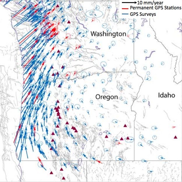
“GNSS Time Series” from the NASA Jet Propulsion Lab website shows horizontal motion vectors taken from a world-wide network of GPS receivers. https://sideshow.jpl.nasa.gov/post/series.html.
Michael Schirber, "’Snowball Earth’ Might Have Been Slushy”, Astrobiology Magazine — August 2015, published online on the NASA Goddard Space Flight Center website, https://www.giss.nasa.gov/research/features/201508_slushball/
Steven J. Whitmeyer and Karl E. Karlstrom, “Tectonic model for the Proterozoic growth of North America”, Geological Society of America Geosphere; August 2007; v. 3; no. 4; p. 220–259.
Robert C. Mahon, Carol M. Dehler, Paul K. Link, Karl E. Karlstrom, and George E. Gehrels, “Geochronologic and stratigraphic constraints on the Mesoproterozoic and Neoproterozoic Pahrump Group, Death Valley, California: A record of the assembly, stability, and breakup of Rodinia”, GSA Bulletin; May/June 2014; v. 126; no. 5/6; p. 652–664; published online 27 February 2014.
Robert C. Mahona, Carol M. Dehlerb, Paul K. Linka, Karl E. Karlstrom, George E. Gehrels, “Detrital zircon provenance and paleogeography of the Pahrump Group and overlying strata, Death Valley, California”, 2014 Elsevier B.V.
Daniel Paul Le Heron and Thomas M. Vandyk, “A slippery slope for Cryogenian diamictites?”, wileyonlinelibrary.com/journal/dep2 The Depositional Record, 2019, 5:306–321.
James W. Hagadorn and Ben Waggoner, “Ediacaran Fossils from the Southwestern Great Basin, United States”, Journal of Paleontology, V. 74, NO. 2, 2000, pp. 349-359.
Marli B. Miller and Terry L. Pavlis, “The Black Mountains turtlebacks: Rosetta stones of Death Valley tectonics”, Earth-Science Reviews 73 (2005) 115– 138.
Oates, Felix Waechter, Dylan Trotzuk and Anthony E. Fallick, Francis A. Macdonald, Anthony R. Prave, Ryan Petterson, Emily F. Smith, Sara B. Pruss, Kaylyn, “The Laurentian record of Neoproterozoic glaciation, tectonism, and eukaryotic evolution in Death Valley, California”, Geological Society of America Bulletin 2013;125, no. 7-8;1203-1223.
Frank A. Corsetti and Alan J. Kaufman, “The relationship between the Neoproterozoic Noonday Dolomite and the Ibex Formation: New observations and their bearing on Snowball Earth”, Earth-Science Reviews 73 (2005) 63–78.
Paul Stone, Calvin H. Stevens, Paul Belasky, Isabel P. Montañez, Lauren G. Martin, Bruce R. Wardlaw, Charles A. Sandberg, Elmira Wan, Holly A. Olson, and Susan S. Priest, “Geologic Map and Upper Paleozoic Stratigraphy of the Marble Canyon Area, Cottonwood Canyon Quadrangle, Death Valley National Park , Inyo County, California”, U.S. Geological Survey Scientific Investigations Map 3298, U.S. Department of the Interior, 2014
Ian Norton, “Two-stage formation of Death Valley”, Geological Society of America Geosphere; February 2011; v. 7; no. 1; p. 171–182.
Wikipedia articles “Geology of the Death Valley Area”, “Snowball Earth” and “Ubehebe Crater”.
Andrew Dunning’s recommended reading list:
• A Trip through Death Valley’s Geologic Past: The Magnificent Rocks of Death Valley (Kenneth E. Enger)
• Death Valley: Geology, Ecology, Archaeology (Charles B. Hunt)
• Geology Underfoot in Death Valley and Owens Valley (Robert P. Sharp and Allen F. Glazner)
• Hiking Death Valley by Michael DiGonnett


Field Trip Director
Annual Newsletter Editor
fieldtrips@gsoc.org